 Catálogo iRIG-Madeira
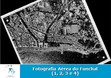
Fotografia aérea do Funchal - 4 serviço de visualização
Serviço de visualização da Fotografia Aérea 4. Fotografia aérea do Funchal (9909?)
Simple
Identification info
- Alternate title
- Funchal aerial photography - 4
- Date (Revision)
- 2020-03-31
Point of contact
Direção Regional do Ordenamento do Território
(+351) 291 231 206
Rua da Sé, n.º 38
,
Funchal
,
9000-066
,
Portugal
(+351) 291 000 410
(+351) 291 231 206
- Maintenance and update frequency
- Not planned
- ISO - 19119 geographic services taxonomy
-
- infoMapAccessService
- Keywords
-
- WMS
- RAM
- DROTe
- infoMapAccessService
- Fotografia Aérea
- Spatial scope
-
- Local
- Place
-
- Funchal
- ISO 19119 service taxonomy
-
- infoMapAccessService
- Access constraints
- Other restrictions
- Other constraints
- Acesso público sem restrições
- Use constraints
- Other restrictions
- Other constraints
- acesso e uso sem condições
- Service Type
- OGC:WMS
N
S
E
W
))
- Extent type code
- Yes
- Geographic identifier
- PT3
Coupled Resource
- Operation Name
- GetCapabilities
- Identifier
- 03a5c293-5fc2-403d-b2ae-37536b84b9e1
- Coupling Type
- Tight
Contains Operations
- Operation Name
- GetCapabilities
- Distributed Computing Platforms
- XML
- Operates On
- Reference system identifier
- EPSG / http://www.opengis.net/def/crs/EPSG/0/3061
- Reference system identifier
- EPSG / http://www.opengis.net/def/crs/EPSG/0/5016
- Reference system identifier
- EPSG / http://www.opengis.net/def/crs/EPSG/0/4326
- Reference system identifier
- EPSG / http://www.opengis.net/def/crs/EPSG/0/5013
- Reference system identifier
- EPSG / http://www.opengis.net/def/crs/EPSG/0/3857
- Distribution format
-
-
WMS
(
1.3.0
)
-
WMS
(
1.3.0
)
Distributor
Direção Regional do Ordenamento do Território
Rua da Sé, n.º 38
,
Funchal
,
9000-066
,
Portugal
(+351) 291 000 410
- OnLine resource
- accessPoint ( OGC:WMS )
- Hierarchy level
- Service
- Extent type code
- Yes
- Geographic identifier
- PT3
- Other
- Serviço
Conformance result
- Date (Publication)
- 2010-11-23
- Explanation
- Ver a especificação citada.
- Pass
- Yes
- Statement
- Não existe certeza da data do recurso acoplado a este serviço.
- File identifier
- 9bb314ed-770b-4ff5-92d0-c0e1c60e0c23 XML
- Metadata language
- PortuguesePortuguese
- Character set
- UTF8
- Hierarchy level
- Service
- Hierarchy level name
- Serviço de dados geográficos
- Date stamp
- 2022-12-07T11:05:15
- Metadata standard name
- ISO 19115 Sistema de Metadados dos Açores
Point of contact
Direção Regional do Ordenamento do Território
(+351) 291 231 206
Rua da Sé, n.º 38
,
Funchal
,
9000-066 Funchal
,
Portugal
(+351) 291 000 410
(+351) 291 231 206
Overviews
Spatial extent
N
S
E
W
Provided by

Associated resources
Not available